


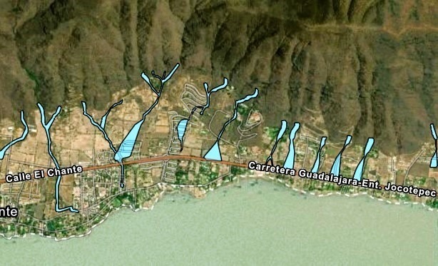
Jocotepec is the municipality in the Ribera de Chapala region with the highest number of landslide-prone areas, registering at least 24 according to the latest update of the Jalisco Risk Atlas. The areas most affected are situated between the hills of San Juan Cosalá and El Chante. The updated Atlas, presented on August 22, highlights these risks, showing lines passing through zones that include buildings, particularly high-end subdivisions, and areas where further development is planned.
Each landslide marker on the map provides detailed information about the location, emphasizing the risks. One notable point is a “waterspout point” located in the hills near San Juan Cosalá, where construction has recently begun, raising concerns about future land stability.
In comparison, Chapala has 11 landslide lines, stretching from the Jocotepec border to the end of Ajijic near San Antonio Tlayacapan. Poncitlán, another area in the Ribera region, has five landslide lines in the vicinity of Mezcala de la Asunción, with the largest affecting the main populated areas.
The updated Atlas was officially handed over by the Civil Protection and State Firefighters to the Governor of Jalisco, Enrique Alfaro Ramírez, during the celebration of National Firefighter Day. Governor Alfaro emphasized the significance of the update, noting that the Atlas had not been revised since 2007. He stated, “Imagine how much Jalisco has changed since then. We invested nearly seven and a half million pesos to conduct a thorough study.” The revised Atlas serves as an essential tool for planning and protecting Jalisco’s more than eight million residents.
The Jalisco Risk Atlas can be accessed online for public consultation at the following link: Jalisco Risk Atlas.